

According to weather forecasts, the UK could experience a bout of extreme weather with ice pellets and freezing rain in the upcoming winter period.
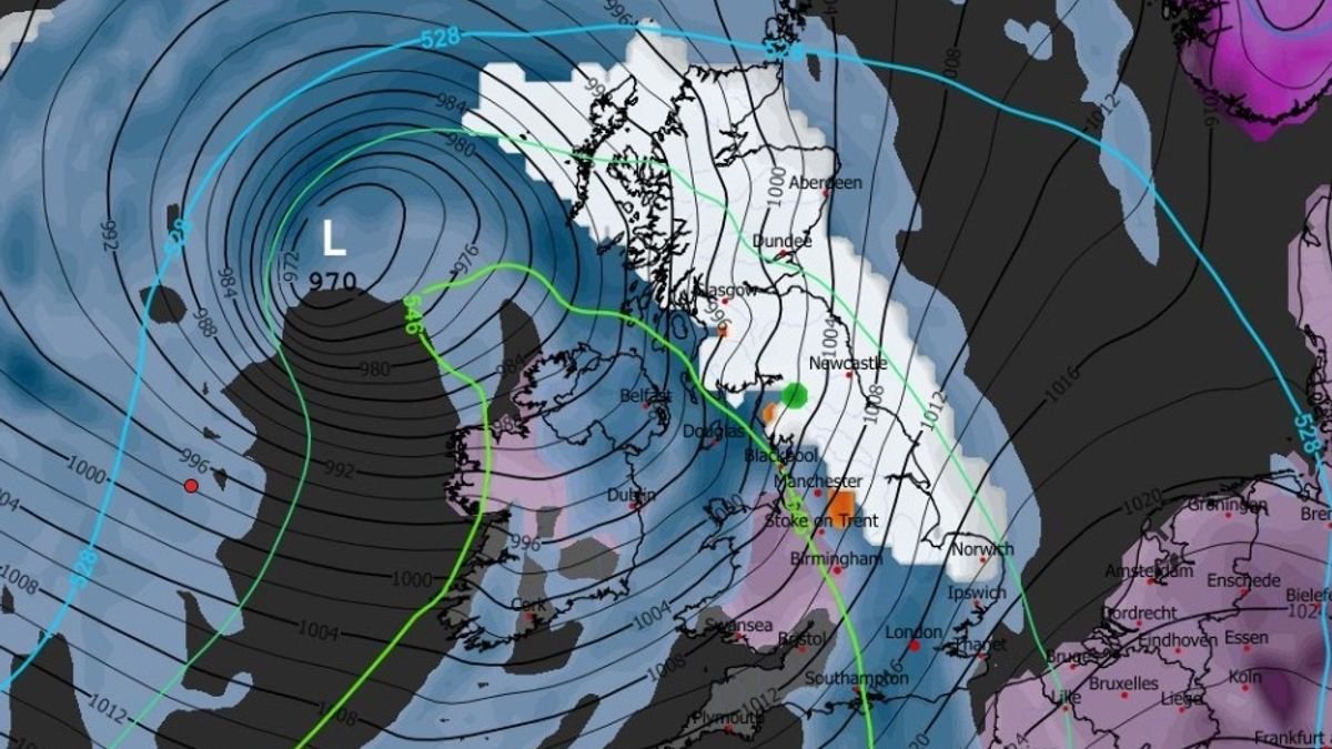
The latest GFS model projections indicate the possibility of unusual and potentially hazardous weather occurrences hitting the UK on February 1, as a mix of snow and rain traverses the nation. The maps suggest up to half an inch of snowfall starting early on February 1, with regions like the West Midlands and the north-west expected to bear the brunt of a snow band extending to Belfast and Glasgow.
Northern areas could witness lighter snowfall, along with isolated incidents of freezing rain highlighted in orange in Snowdonia. By mid-morning, heavier snowfall might move towards the north-east, East of England, and eastern Scotland, with additional pockets of freezing rain predicted around the Peak District and Ayr.
Green markings on the maps indicate the likelihood of ice pellets near Carlisle and the Scottish Borders. Subsequently, the forecast shows snow advancing northwards towards eastern Scotland by noon, while the rest of the UK, except London and parts of the south-east, is expected to experience rainfall instead. Freezing rain could impact areas around Loch Lomond and Northumberland.
The Met Office’s extended forecast for the period spanning from January 24 to February 2 suggests a shift towards colder conditions, raising the potential for snow, especially on elevated terrain in Scotland and northern England.
According to the Met Office, freezing rain occurs when snowflakes melt in warm air, transition to rain, and then refreeze upon encountering cold air. These supercooled water droplets, despite being below freezing, maintain a liquid state as they fall.
Freezing rain can create hazardous icy patches on surfaces, posing risks for transportation and causing potential dangers for aircraft, vehicles, and pedestrians on roads and walkways.
Furthermore, the weight of ice accumulation can lead to structural hazards, such as tree branches and power lines snapping or breaking under the added load, as highlighted by the National Weather Service in the US.
Ice pellets are formed when snowflakes partially melt during descent, then refreeze into granular particles upon passing through sub-freezing air. The Met Office notes that ice pellets, denser than snow, can accumulate on the ground, resembling a compact covering, albeit smaller and less solid than hailstones. Ice pellet showers typically have a short duration.
For quick access to valued news, select Daily Mirror as a ‘Preferred Source’ on Google News.
At Reach and across our entities , we and our partners leverage data obtained via cookies and other identifiers from your device to enhance site experience, analyze usage patterns, and display personalized ads. You can opt out of data sharing or selling by clicking the “Do Not Sell or Share my Data” button at the bottom of the webpage. Remember, your preferences are specific to each browser. Your use of our site and services indicates acceptance of <a data-testid="cipa-cookie-notice-link" href="https://www.mirror.co.uk/cookie-policy/" rel="noreferrer" target="_